Thursday, 27 March 2014

Swan River Bicycle Ferry


Could the bicycle-ferry be a solution to Perth's traffic congestion?


I have an idea. A ferry from Point Walter jetty in Bicton to the Nedlands jetty. There is nothing new with that, people have been asking for more ferries on the Swan River for a long time. When trains are cancelled, or when road congestion gets particularly bad, the idea sometimes gets some airing in the media. What has been missing in the previous discussions has been bicycles.

My proposal is for the ferries to be specifically designed to carry bicycles in addition to people. This would be at all times of the day, unlike Perth's trains that have to exclude bicycles during peak times. They would have easy roll-on, roll-off access and good bicycle racks on board. This will allow the rider to do all the handling of the bicycle and ensure a fast service.

Swan River showing Point Walter to Nedlands route


By designing the service for people riding bicycles, the catchment area for potential passengers is greatly extended compared to walking and will help overcome the problem of lack of urban density at each of the ferry terminals.

This rough map of the Point Walter area shows the distances for ten minutes walking compared with ten minutes riding a bicycle.

Point Walter and surrounding district

Up to now, Perth's low urban density and car-based “park and ride” thinking has prevented ferries being established as viable transport links. The residents of the expensive riverside neighbourhoods would not be in favour of large car parks radiating from their local jetty in the way that currently happens at Perth’s train stations. With a bicycle-based plan, no additional car parking is required.

The Nedlands jetty is an easy one kilometre ride to the University of Western Australia. The huge QEII Medical Centre is only three kilometres using the existing separated shared paths, or 2.5 kilometres if you are happy to use the road. Subiaco is five kilometres away and you can get to the Perth CBD from the Nedlands jetty using a fully separated shared path beside the river.

QEII Medical Centre employs many. This is just the car park.

Once the service is established, the ferry service could be extended to link through to the Perth CBD at Barrack Street but adding this extra leg to the journey would probably double the number of vessels required to maintain the same frequency. 
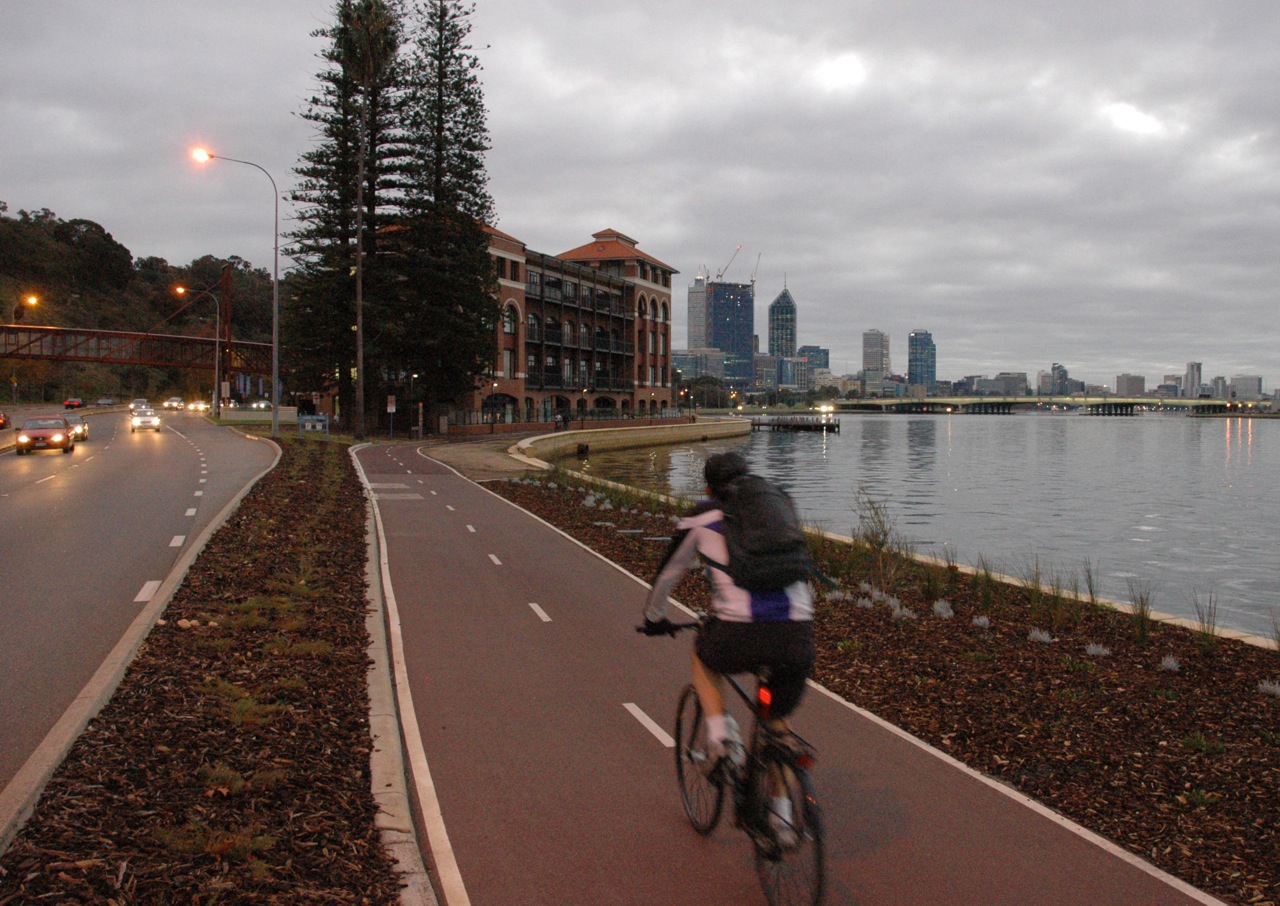
Shared path from Nedlands to Perth CBD

The combination of ferry and bicycle could result in journey times that are similar to car travel at peak times. For example, a person living in Bicton who works at QEII Medical Centre in Nedlands could get to work using the following methods:
  1. A 20 km bicycle ride around the river using the shared paths. 60+ minutes.
  2. Two buses, plus walking. 50 to 70 minutes.
  3. Car via Stirling Highway. 30 to 40 minutes depending on traffic and time of day.
  4. Bicycle ride for 2 km on suburban streets, the bicycle-ferry 4 km, bicycle ride for 3 km on the separated paths next to the river and Kings Park.  45 minutes.


Transperth, the Western Australian State Government transport authority would be the logical service providers. The ticketing could be done using the excellent Smartrider automated ticket system and the Transperth journey planner could be expanded to include travel times for bicycles. Transperth would also have the ability to adjust their buses to connect with the ferries for those disadvantaged souls who don't own a bicycle.

In fact, the existing Transperth ferries would need very little adjustment to make them suitable. Transperth currently has two ferries which provide a shuttle service between South Perth and the Perth central business district. These ferries already have a section allocated to carry bicycles, but only four per trip.

Current bicycle rack

To provide a viable Point Walter to Nedlands bicycle-ferry service, Transperth could continue with the same type of vessel and simply adjust the interior seating arrangement. The current configuration has seating for 122 people, some clear areas for prams and wheelchairs, plus a rack to suit four bikes. A new configuration could provide capacity for 30 bicycles and still have room for about 70 people. A good capacity is essential for the ferry to function as a reliable service for people riding bicycles. The current South Perth to Perth CBD service will not accept bicycles on-board once the four places are filled. This might be OK for a ferry that takes tourists to the zoo but not for a commuter orientated Point Walter to Nedlands route.

Bicycle storage area in foreground

Apart from the South Perth to Perth CBD ferry, there are no regular ferries operating on the Swan River. This will seem surprising to anyone not living in Western Australia. Having a city of 1.8 million  people surrounding such an impressive body of water you would expect us to have several transport connections using ferries but it has not happened.

The population of Perth’s metropolitan area has expanded along the rail and road corridors. The urban density near the river is generally low, apart from the CBDs of Perth and Fremantle. This lack of density is one of the main reasons conventional ferries routes have not been expanded on the Swan River. 


Perth city from South Perth

There was an attempt at a passenger ferry between Fremantle and Perth about ten years ago. It was a commercial non-government operation and failed because not enough people used the service. Although it would have been a pleasant way to travel, the journey time by train is 27 minutes compared to around 50 minutes by ferry. There are some speed restrictions on the river that prevent the ferries travelling fast, particularly near the Fremantle end. At any of the ferry-stops between these two relatively dense urban areas there would have been very few passengers. I think the frequency of the ferries was also low because the operators only had one or two vessels making the complete journey. It would have been a long wait between trips and passengers would have needed to plan their journey carefully.

I am not an expert, but I know an important part of getting public transport to succeed is getting the trip frequency to a level where passengers do not have look at timetables.  A more frequent service could be achieved by not going all the way to Fremantle and avoiding the slow and narrow section of the river. The section of river between Point Walter and Nedlands is wide and therefore has very few speed restrictions. The distance between those two jetties, at approximately four kilometres, is relatively short which allows both a fast and frequent service to be provided with fewer vessels. It will be more efficient to just operate between these two points instead of trying to provide a Perth to Fremantle ferry.

A gut-feeling tells me a bicycle-ferry could make a very effective transport link for a relatively low infrastructure cost. There are existing jetties at both locations. Ideally the jetties would be upgraded with adjustable decks to allow entry at the same height, but a service could get started without doing that modification. The South Perth to Perth CBD ferry is operated but just one person, yet is able to provide a level entry for people in wheelchairs because the jetties have the ability for height adjustment. Wheeling a bicycle on board is no problem.


Jetty height matched to ferry


The Point Walter to Nedlands connection could be the first part of a bicycle-ferry network. The next stage could be a link from Point Walter to the Claremont jetty. The map below shows four private secondary schools and a university campus within two kilometres. There are thousands of students attending these schools. How many get driven by car from homes that are south of the river? School traffic creates a lot of congestion on Stirling Highway. This ferry link could help save the highway from the current plans to have it reamed wider to resemble a freeway.

Claremont Jetty linked to Point Walter 

Here is a list of the schools within bicycle riding or walking distance of Claremont Jetty:
  • Christ Church Grammar School - 550m
  • Methodist Ladies College - 1 km
  • University of Western Australia Claremont Campus - 1 km
  • Scotch College - 1.5km
  • Presbyterian Ladies College - 2.6 km
  • John XXII College - 3.4 km
  • St Hilda’s Anglican School for Girls - 3.6 km
  • Shenton College - 4 km (17 mins)
And some other places:
  • Bethesda Hospital - 400m
  • Claremont Quarter Shopping Centre - 850m
  • Claremont Showgrounds - 1.5 km
  • Swanbourne Beach - 3.4 km
All these destinations could be connected by bicycle to the suburbs of Bicton, Palmyra, East Fremantle and Attadale with the addition of a bicycle-ferry.


One final point: these new ferry services should not be half-done. They need to have a frequency and time span that will give reliability to commuters and make it easy for people to adjust to not using a car. I'm thinking: 6am to 9pm from Monday to Friday. Departing every 15 minutes during peak hours and every 30 minutes at other times. Weekends 8am to 7pm every 30 minutes.

Road congestion in Perth has increased in recent years and some of Perth's best bicycle infrastructure is beside the river. Our population is growing rapidly. Perhaps now in the right time to expand our transport network onto the river and combine it with the flexibility of the bicycle.

Do you think a bicycle-ferry between Bicton and Nedlands has a good chance of succeeding? Would you use it?  Am I dreaming?  Let me know your thoughts.

Swan River and Perth CBD


Tuesday, 18 March 2014

Black-spot under construction

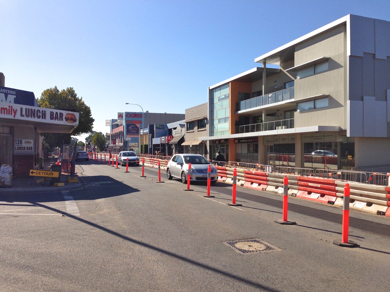
Part of Cambridge Street is having a make-over. It is a section about 400m long in the inner-western suburb of West Leederville. This area is controlled by the local government authority, the Town of Cambridge, who state the aim of the project is "to create a pedestrian friendly precinct along Cambridge Street, while retaining it as a traffic route". Unfortunately there is no consideration to accommodate bicycle traffic and the changes will result in more dangerous conditions for riding.

Cambridge Street, West Leederville

The existing road had two lanes in each direction. The centre lanes carrying the majority of traffic and the outside lanes having a mixture of parking bays, loading zones, bus-stops and no-standing zones. These outside lanes were only used for continuously moving traffic in peak-hour periods. I had noticed in these peak times the traffic volume did not seem to justify having two lanes in each direction. The people at the Town of Cambridge must have agreed because their plan is to reduce Cambridge Street to one lane in each direction.

This might appear to be a modern approach: restricting the movement of motorised traffic and allowing more space for other modes of transport. However once the roadworks are complete, motorists will barely notice a change; pedestrians may have some improvement; and bicycle riders will be worse off. This is more of a landscaping exercise than a revision of traffic management. The project is like something from the 1980s.

Site plan


For motorists, the "one-lane" design will have additional right-turn pockets and the left turns will have a radius that allows for fast cornering. This will ensure the usual traffic flow.

Pedestrians will have wider footpaths in some areas and some wider central islands, but the dropped-curb crossing points will be away from the desire lines at several places.

Kimberley Street

Why will the new design be worse for bicycle riding? In practical terms, for the full length of Cambridge Street, the existing outer lane acts as a bike lane where there are no parked cars or vehicles in loading bays. It is not an ideal road, but motor vehicles can pass a bicycle without too much problem. There are plenty of sections where bike riders can move closer to the curb using the outer lane while the motor vehicles stay in the centre lane.

Google view, January 2010


Google view, January 2010

Once the modifications are completed in West Leederville, the new 400 metre-long section of Cambridge Street will have an almost continuous row of central islands and the outer lane will be gone. The carriageway will only be 3.2 metres wide. Bicycle riders need one metre, trucks and buses are 2.5 metres wide. That is 3.5 metres without allowing for a gap. With a carriageway of 3.2 metres, there simply is not enough space for both, and overtaking will not be possible.

Specification from Cycling Aspects of Ausroads Guides

Those people on bicycles who feel brave and are able to deal with aggressive drivers can take-the-lane and hold back the traffic. A bit like a rolling roadblock. The rest will need to get off and walk or avoid the place completely.

This situation is almost ridiculous. I wondered how the Town of Cambridge got to a position where bicycles have been excluded from what is meant to be a revitalised "high street" precinct. If we look back to the Town of Cambridge Bicycle Plan 2009 (PDF link) we might have the answer. It was done by the company Shawmac Pty Ltd who are civil engineers, traffic engineers and risk managers. In reference to Cambridge Street (page 39) it was noted that there were no bicycle facilities provided and the:
"Road environment not conducive to on-road facilities. Off-road facilities not recommended due to land use. Adequate parallel east-west routes provided."
The plan was to ignore Cambridge Street and provide a PSP (principal shared path) beside Railway Parade which is one block to the south and runs parallel. It has not been built yet. If it eventually gets done, it might be useful for commuting bicycle traffic but it will not much help if you want to visit the businesses on Cambridge Street.

In contrast to the Town of Cambridge Bicycle Plan 2009 there is another document that details an alternative option for Cambridge Street. The West Leederville Planning & Urban Design Study Transport Report (PDF 2.3 MB) done in December 2010 by Sinclair Knight Merz Pty Ltd recommended a bicycle route along Cambridge. You can see it shown by the pale blue line on page 81 of the report below.  This report had a more holistic approach and examined the improvements that could be made to the transport network and their potential to benefit the community.


West Leederville Stage 2 Transport Report

You can also read in the note in the box where the Town of Cambridge council has decided not to accept the recommendation of this report and preferred to stay with the earlier 2009 bicycle plan. It appears to be a case of town planning versus traffic engineering. The traffic engineers won.

There are a couple of odd things in the Town of Cambridge Bicycle Plan 2009. After stating there were adequate east-west routes parallel to Cambridge Street, later in the document (page 63), when explaining long term requirements,  Shawmac say the east-west links need improving:
"The major changes required to the existing Town of Cambridge Bike Plan predominately centres on providing stronger east-west links. The current north-south links are reasonably well catered for. Given the nature of the east-west streets throughout the Town, provision of cycle facilities has been restricted by commercial development, pavement width, on-road parking, property access, public utility installations (eg Western Power poles) and verge improvements (eg trees)."
The 2009 plan also includes a record of crash data provided by Main Roads WA. It gives information about all the crashes involving bicycles with motor vehicles in the 22 square kilometres of the Town of Cambridge for the five years leading up to December 2007. Fourteen percent of the crashes were in Cambridge Street.

There is enough room on Cambridge Street to have a protected bicycle lane from West Perth to City Beach. Imagine that. One lane for motor vehicles and one for bikes. All the way.

The discussion about Cambridge Street should be about the merits of a protected lane versus an on-road lane. Not about there being no provision at all.


Monday, 7 October 2013

How to use an Australian roundabout

Bicycle riders are quite rare in Kalgoorlie. Recently, while I was walking around the town I spotted one and felt compelled to take a photograph.  A bit weird I know, I guess the impulse is comparable to an ornithologist seeing a rare bird.


By the time I got to the corner he had given up trying to enter the roundabout on his bicycle.  He had dismounted and resorted to crossing as a pedestrian.  The traffic was moving quite fast and he had to wait quite a while.  As a pedestrian he had no rights and it is very difficult to judge when a motorist is going to exit the roundabout because they usually do not use their turn indicators.


Growing frustrated, he took off on foot to an easier place to cross.


After crossing he resorted to illegally riding along the footpath.

And finally got to the bookshop which was only a few metres from his original position.


This person is an adult male who I expect would have a reasonable sense of self confidence in most situations.  He also, obviously, has a sense of self preservation and recognises that an Australian roundabout is not a safe place on a bicycle. 

There is a small percentage of the population that have the confidence and skill to dodge motor vehicles but the majority of people do not. This man represents the majority. Most of the people without the confidence simply do not ride. I congratulate him for his efforts and wonder how long he will tolerate the difficulty of riding around the city before he resorts to driving a car.

Our state and local governments should not keep building roundabouts with the current design while hypocritically telling us how much they are doing for sustainable transport.


Saturday, 5 October 2013

The view is better from a bike

This week I spotted a lake on my way to visit the Subiaco council to discuss crosswalks. It is hidden behind a hedge. You can see it if you are riding a bicycle but would completely miss it from the seat of a car.

The view from a bicycle

The view from a car

Monday, 9 September 2013

The stupid roundabouts in Kalgoorlie

You may know I dislike roundabouts. I have written about them previously.  The City of Kalgoorlie has a unique dangerous version for anyone on a bicycle.  At first glance there seems to be a convenient bicycle lane on the approach to the intersections.


Don't be fooled, it is really just an odd type of drain with traffic island.  It is designed to force motor vehicles into a narrow lane as they enter the roundabout.  Across the top of the drain is a steel plate with sharp edges.


The plate is a continuation of the footpath, it is used instead of having ramps. The streets are very wide and these steel plates are positioned directly across the desire line when riding.


This is not just a one-off, these things are everywhere. Sometimes they are positioned on the exit from a roundabout, sometimes on the entry. Almost always, exactly where we would want to ride.


Saturday, 7 September 2013

Why does Canberra have more crosswalks than Perth?


Today is Federal election day in Australia. A good day to compare Perth with Canberra.  
A big building with a flag
I recently made a trip to the national capital as a parent / helper with my daughter’s school class.  Our government provides some financial assistance for children who visit the capital on school excursions. There is a quite a business in providing support for touring school groups in Canberra. The city has nearly 130,000 school children visit each year. I have to admit Canberra had not been high on my list of cities to visit. My only previous experience was as a small child so this trip felt like the first time. All I could remember was wide streets and lots of space, however I really enjoyed the week and realised that apart from its obvious political significance it has some great museums and art galleries. 

Model of Canberra
It was also interesting to get some understanding of the city layout. Canberra did not evolve over time, it was purpose-built as a national capital in the early part of last century. Basically built from nothing, the location was a compromise between the rival cities of Sydney and Melbourne, Australia’s largest at the time. Before 1900, Canberra was just grazing land, now it is our eighth largest city and has a population of around 360,000.

The city was designed after the invention of the car and my first impressions are that it is still a city for cars. There seems to be a lot of tunnels, flyovers and big sweeping roundabouts. Lots of double lane roads. Is it my imagination or is Canberra trying to hide its car dependence? Shouldn't Parkes Way really be called Parkes Freeway? It seems like a freeway. Shouldn’t Belconnen Way be called Belconnen Highway? Also, who named the big road heading south Tuggeranong “Parkway”? In most Australian cites, eleven kilometres of multiple-lane road with a speed limit of 100 km/h and grade separated interchanges would be called a “Freeway”.

Tuggeranong Parkway, no park here

And if you hide the parking areas behind hedges, does it feel like you have less cars?

Hiding the cars

...still hiding
Our schedule for the week was very busy. I had no opportunity for bicycle riding but I did notice a lot of on-road bicycle lanes while driving around. Canberra does have a lot of space, it seems a shame that more effort is not made to provide separated infrastructure. This freshly painted example on Wentworth Avenue is interesting. If you look at the same spot on Google maps it shows the road is the same width in 2008 but without the sign and painted line. 

Wentworth Avenue, Canberra 2013

Wentworth Avenue, Canberra 2008 (from Google Streetview)
I bet after this effort, a couple of bureaucrats congratulated themselves for ticking-the-box for "provision of sustainable transport options" then went to lunch. 

I suppose it is a slight improvement but this is a 60 km/h road. My teenage daughter does not use bicycle lanes like this. Instead of just adding a sign and some paint, the ACT government could have made an actual improvement by separating bicycles and motorised traffic. There is ample space available.

Wentworth Avenue, Canberra from above.


This blog post is turning into a ramble. If you want to read more about Canberra's transport issues try these: "Fifty Years of Transport Planning in Canberra" Mees, 2012 (PDF 229kb) and Transport Policy at the Crossroads, Mees & Groenhart 2012 (PDF 418 kb)

Now onto the subject shown in the title: Why does Canberra have more crosswalks than Perth? Pedestrian crosswalks are a rare item in Perth. Why is that? Is walking less important in Perth?

Here is a comparison: the districts of Manuka in Canberra and Subiaco in Perth. Both areas have things in common: shops, restaurants and a major sports ground. Manuka appears to be a fashionable area and Subiaco, although in decline, is still one of the preferred places to live and visit in Perth.  Manuka's retail and restaurant area has eight pedestrian crosswalks, all within a few blocks. Subiaco has one.

Manuka, ACT.  Crosswalks shown with green squares.

Subiaco, Western Australia.  One crosswalk.
I visited Manuka on a Friday night. Every restaurant and bar was buzzing with activity. The footpaths were not busy but it was a chilly three degrees. It was a great pleasure to find so many crosswalks.
Manuka

Manuka (Google Streetview)


Subiaco has places where pedestrians can attempt to cross the road but these are not crosswalks. There are no zebra stripes and drivers of motor vehicles have right-of-way at all times.  It does get confusing, the road design implies a pedestrian crossing so the City of Subiaco has tried to fix the problem with extra signs to remind pedestrians they have no rights.

Subiaco. Pedestrians have to wait.
Signs remind pedestrians they are less important.

However, there are no signs for motorists. They are often confused and sometimes stop for pedestrians.

Traffic might stop, if you have a walking frame it helps.

These next two photographs sum up the situation in Subiaco. Stand and wait while people in big cars cruise past. Then, when you make your move, be on guard and move fast.

Rokeby Road Subiaco today.
On guard Rokeby Road Subiaco.
Why do we accept such poor conditions in Western Australia?


Update Monday 9 September: Subiaco's only crosswalk is currently unusable.
One becomes none


Sunday, 18 August 2013

Comparing Perth and Melbourne for pedestrians


On a recent trip to Melbourne I was impressed by how much easier it is to be a pedestrian in that city. What makes it better? One of the main advantages is it takes less time to cross a road. This is achieved by using the parallel crossing system at traffic lights. Put simply, pedestrians are allowed to cross a road in the same direction as motor traffic, at the same time. This means for every phase of traffic control there is an option for pedestrians to move. Motorists wanting to turn must wait until all pedestrians have crossed the road before making their move.

In Perth, at most busy intersections, pedestrians have to wait until we get our own special time to cross. All motor traffic is stopped, then pedestrians can go in any direction. This exclusive system for pedestrians is safe but it also means much longer waiting times. Pedestrians have to wait while motor traffic goes north-south, then east-west, then sometimes there is an extra turning sequence before everything stops and the pedestrians get a turn.

The parallel crossing system works in Melbourne because people driving vehicles give-way to pedestrians when turning. In Australia, traffic laws can vary slightly from state to state but this rule is the same for Perth and Melbourne. We have a problem that most Perth drivers are ignorant of this law and the Western Australian Police do very little to enforce it. 

A Melbourne taxi driver waits patiently to turn


Here is a comparison. This first video shows an intersection in the Melbourne district of South Yarra. There are pedestrian crossing options about every 35 seconds. The longest wait for a pedestrian is 1 minute 10 seconds. Notice how the driver of the small black car waits for the pedestrian. That is not likely to happen in Perth.


This next video shows a similar intersection in the Perth district of Mount Lawley. Both South Yarra and Mount Lawley are busy areas with a mixture of residential and commercial activity just a few kilometres from the central business district of each capital city. In Mount Lawley there is no pedestrian crossing option that runs parallel with the traffic. This means no short waiting times, whatever direction you want to travel. All pedestrians have to wait for the exclusive pedestrian-only phase which means a wait of up to 1 minute 50 seconds. 

People in Perth often wait three times longer to cross the road than people in Melbourne.


You might think at least with Perth's exclusive pedestrian phase a diagonal crossing can be made in one trip thus avoiding the extra waiting time, however this only works if you are a quick walker and get a lucky break by not having to wait too long before the pedestrian phase. Older people and those with children are not likely to attempt a diagonal crossing in Perth. There is not enough time to make the crossing before the lights change and you are at risk of being killed or injured.

The older man with the walking frame at the start of the Mount Lawley video takes 25 seconds to cross the road. This is barely enough time to cross at the shortest point, he would not attempt a diagonal crossing in one go. For this person a diagonal crossing at these Mount Lawley traffic lights would have to be done in two parts and would take somewhere between 2 minutes 20 seconds if he got lucky, but it is more likely to be longer and take up to 4 minutes 30 seconds with most of the time spent standing watching cars go past.

In Melbourne's South Yarra, this same two-part crossing, done to reach an opposite corner would only take him 60 seconds!  A 25 second walk, a 10 second wait and then another 25 second walk.

It gets worse. Have a look at our central business district. This next video shows the intersection of St Georges Terrace and Milligan Street Perth. This is the oil and gas end of town. On one corner is the 40-storey QV1 tower and on another is the 29-story Woodside Plaza building. They have about 100,000 square metres of lettable floor space between them. On the opposite corners are a park and a boutique hotel plus there are other multi-storey towers nearby. This combination should result in a lot of pedestrian activity but it is relatively quiet down on the street. Perhaps it is because it can take up to 2 minutes 20 seconds just to cross the road.


This intersection has an extra phase of motor vehicle flow so the pedestrian-only phase takes longer to come around. The wait is so long some people ignore the rules and cross against the 'Don't Walk' sign. You can see a woman in black doing this at around 1' 35".

The pedestrian-only phase with diagonal crossing has different names around the world. It is sometimes called a "pedestrian scramble" or a "Barnes dance".  This Wikipedia page gives some further reading. Contrary to my observations here, there seems to be a general view that these pedestrian-only phases are an advantage to pedestrians. Providing amenity and safety over the dominance of motor vehicles. As with roundabouts, which I have written about previously, there are a number of ways to interpret and execute traffic control systems. The version of the pedestrian scramble we have in Perth is safe but the long waiting times followed by very short crossing times dissuade people from walking.

The following scramble intersection in Toronto has a different execution. They have the pedestrian-only scramble at every third phase but also allow pedestrians to cross in parallel with the motor traffic during the other phases.


The Sustainable Transport Coalition of Western Australia produced a paper in 2003 about the introduction of parallel phase pedestrian crossings in Western Australia. It is still available to download from their website. They expressed concern about the safety of pedestrians and complained about the poor implementation of the system by the Western Australian state government's department of Main Roads. It seems that not a great deal has changed in the past ten years.

It would be interesting to compare the pedestrian death statistics between the two cities. Even though Perth's pedestrians have to wait longer, do the exclusive pedestrian phases make walking safer than Melbourne's parallel system?  The only figures I could find compare the whole states: Victoria and Western Australia. Victoria has a higher population but once the figures are adjusted for that, on average, there is not a lot of difference. Western Australia has slightly more deaths. I got the figures from the BITRE Road Deaths Australia 2011 Statistical Summary (3.6 MB PDF).


The death statistics do not tell the full story about vulnerable road users in Australia. Lowering the number of deaths of pedestrians or cyclists means nothing if there are less people participating in those modes of transport. Governments should not congratulate themselves on achieving a lower road toll if they continue to create road environments that discourage walking and bicycling.

Intersections with traffic lights in Perth and the rest of Western Australia can be confusing. There are a range of different systems in place at various locations. The pedestrian-only scramble is not done at every intersection. There are some traffic lights with 'Walk' and 'Don't Walk' symbols and others with nothing. The intersections without the scramble phase are hazardous because of the risk of being killed or injured from turning vehicles.

However, expanding the use of pedestrian-only scramble phases at traffic lights is not the solution to better pedestrian amenity and safety. The major issue that needs to be addressed in Western Australia is the non-compliance by motorists of the law:

GIVE WAY TO PEDESTRIANS WHEN TURNING.

If motorists obeyed this law it would make life in Perth so much better. Intersections with traffic lights are the minority:  at the many thousands of intersections without traffic lights, pedestrians are also put at risk from motorists making illegal turns while they are crossing the road.  

Enforcing this law will probably not make a huge difference to the road toll.  The people who walk around Perth generally do not put themselves at risk. They are mostly cautious and vigilant of the two-tonnes of metal that are thrown around corners without warning. It is not very pleasant to always be on guard, to remember to watch over your shoulder every time you cross a minor street or driveway. Therefore, many people (too many) simply do not walk, it's not pleasant, it's too stressful and it takes too long. 

Town of Cambridge sign

The catalyst for change will not come from the state government Office of Road Safety. They measure their success on lower injuries and fewer deaths. This needs to be a whole of government approach. Less aggressive motorists and a better environment for walking will have benefits for tourism, health and the economy. Some traffic engineers also think those parallel walk lights at intersections are better for congestion as well.

If our state government would finally recognise the problem then act to educate the public and simply enforce the law, our quality of life could be improved immensely.

Pedestrians weave through cars in West Perth