Showing posts with label pedestrian. Show all posts

Saturday, 5 March 2016

Museum Street opportunity

The City of Perth is digging up Museum Street, Northbridge. It's a short connection about 100 metres long between Aberdeen and Francis Streets. The work is a complete rebuild which includes new trees, lighting and realigning kerbs. Information is available on the city website.

It will be an improvement for pedestrians and create another space for the students from the adjoining colleges to sit during breaks. For people riding bicycles it is an incredibly poor design. Why is the City of Perth still excluding bicycles from planning decisions?

This is the artist impression of the completed works. The car lane is narrow and one-way. Any bicycle traffic is suppose to use a 'shared path' on the right. You can't see it? It's meant to be somewhere among all those people, trees and furniture.

Museum Street proposal
Confident people on bicycles will take-the-lane in front of cars when travelling north rather than tediously meandering through pedestrians and furniture. For those travelling south I would not be surprised to see riders sprinting along the street illegally if there are no cars coming. Bad design encourages antisocial behaviour.

Here is the 'before' street plan.


Here is one layer of the 'after' plan showing the proposed widened footpath on the left. It is achieved by removing one vehicle lane and eight parking bays. The footpath will be designated a 'shared path' which means you can ride on it but pedestrians have priority.


What the image above does not show are the new trees and furniture. Once those obstructions are added the sub-standard shared-path becomes almost useless.


A more correct image of the proposal would show the bicycle riders who will be forced to push past people sitting and talking. They will have no choice. This 'place activation' will suffer from bad design that does not respect everyone's needs.

My corrected version

Even without the trees and furniture, a shared path in this position is a poor design option. A person riding along the existing bicycle lane on Aberdeen Street needing to turn into Museum Street will not easily recognise the change to a shared path. Bicycle paths should be continuous and intuitive.

Museum Street is located in the middle of the Central Institute of Technology. Similar to a university, it's a modern open-style campus with seven buildings grouped around Aberdeen and Museum Street. There is a high percentage of teenage students, and considering the lack of quality paths, there are quite a lot of bicycles used for transport.

CIT Building 6, 19 Aberdeen Street

CIT Building 1, 25 Aberdeen Street

Immediately to the south of the campus is the State Library, Western Australian Art Gallery and Western Australian Museum, State Theatre and Perth Railway Station. Museum Street is an important access route between the campus and all those other facilities.


The idea to improve the amenity of the street has merit. The old street layout was very wide and unwelcoming. However, it did allow access for a person riding a bicycle in either direction, there were no pinch-points and it was relatively safe because of the extra width.

Museum Street, via Google Streetview

It is difficult to understand how a local government can undertake these expensive street works and virtually ignore the movement of bicycles. The City of Perth likes to brag about how much money they spend on bicycle riding in the city but they obviously still do not understand the basics of what is required. If the City of Perth is genuine about improving bicycle riding infrastructure, each time a street is dug up best practice should be applied to the new works. Most times it will not cost any more, it is just a matter of adjusting the priorities and applying good design.

It is disappointing when we wait for years for improvements to streets, but it is worse when it finally happens and our money is being spent the wrong way.

A summary and a solution


The 'before' version of Museum Street prioritised motor vehicles. It was tolerable for bicycle riding and pedestrians. It was not a destination.

With the City of Perth's enhancement Museum Street will become a destination. Pedestrians will have an improved experience. Motor vehicle access will be reduced a little. However, bicycle riding will be obstructed. This imbalance should be corrected. 

Most of the construction work has been finished at Museum Street but there is still a simple solution available. Motor vehicle access should be prohibited and that lane changed into a bi-directional bicycle path. This could be done by adding a single bollard at each end of the street. Motor vehicles do not need to be driven on this street. The car parking spaces are not required either, there are 614 bays underneath the library just 100m away.

With a bicycle-friendly enhancement of Museum Street it will become a better destination. There will be no noise and fumes from vehicles. People trying to enjoy the space will not be hindered by riders needing to use the footpath. Pedestrians will also have a better experience. People on bicycles will be to be able to move safely and easily along the street in both directions. Motor vehicle drivers will hardly notice any difference. This is what it would look like. Call the City of Perth and ask for the change.

The bicycle-friendly version. Easy.


Wednesday, 21 May 2014

Perth's Worst Pedestrian Crossing?

You have to go out and walk the streets to get a full understanding of the city. Last week, without planning, I discovered what must be Perth's worst crossing for pedestrians.  It may be Australia's worst! I challenge you to find any traffic intersection that takes longer than 6 minutes 30 seconds to cross.

Great Eastern Highway / Hardy Road Belmont

This is the corner of Great Eastern Highway and Hardy Road in Belmont. To cross from the motel to the BP Service Station and convenience store across the road, the traffic lights have been designed to prevent you taking the direct route. You have to cross five roads instead of one. This is 23 traffic lanes, including the two slip lanes and two bicycle lanes.

It is quicker to drive the 100m to this store.
Green is the desire line. Red shows the required route.

The most difficult part is trying to cross the highway. After waiting and finally getting the 'green man' symbol, you only have six seconds before it changes to red and starts flashing. I was not even one- quarter of the distance across before this started happening. I still had eight lanes ahead of me!

We are meant to continue walking and finish the crossing. I had a few seconds of panic and almost turned back. It is very intimidating to walk in front of four or five vehicles when you think they are about to get a green light any second. The drivers, hidden behind the dark tinting and reflections on windscreens, become anonymous. There is no opportunity for eye contact.

I'm reasonably fit, and I did make it to the other side before the lights changed for the cars, but I had no way of knowing if I would make it across safely.

A long way to cross

Instead of having the aggressive flashing 'red-man' signal it would be much more useful to have a countdown timer to give an explanation about how much time is left to cross the road. It would be particularly useful on major roads where the crossing distances are long. Countdown timers are used in many places around the world, including South Australia and Queensland but not in Perth. It appears our department of Main Roads are "considering a trial".

Countdown timers would ease the fear of crossing but they will not reduce the time it takes to go from the motel to the store caused by the circuitous route.

This section of Great Eastern Highway recently had an "upgrade".  $280 million was spent to add two more traffic lanes, plus bus lanes, on-road bicycle lanes (rarely used), slip lanes and wider, faster turning for side streets. The length is 4.2 km and it cuts through the suburbs of Rivervale and Belmont.

Great Eastern Highway 2014

It is interesting to look at Google images showing the highway before the changes. The dropped kerb and cut-away through the centre island indicate a direct crossing between the motel and the BP store was previously available. It appears this option for pedestrians has been removed to accommodate the two new slip lanes that allow faster turning for motor vehicles.

Google Street View 2009

The proposed benefits to the community for the widening of Great Eastern Highway included providing "facilities for pedestrians and cyclists with greater access and connectivity". 

This sales spin would be done to placate any opposition during the development phase of this style of road building. It is obvious Great Eastern Highway has been changed to facilitate moving a huge number of motor vehicles as efficiently as possible, with only token consideration for the communities on each side of the highway.

The people responsible for this should take a walk with their mothers, and try and cross the road.


Monday, 31 March 2014

Parking, pedestrians and government borders

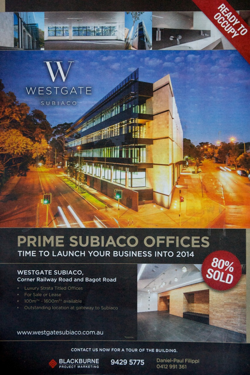
Here is a recent press advertisement for a new office building in Subiaco. The developers and photographer have found the best angle for the building to make it look good and help sell the office space. That camera position is about ten metres off the ground, at the second floor level. None us will ever see the building from that angle unless we hire a cherry picker and stand in the bucket high above the middle of the road.


This is how it appears for pedestrians at eye level. Not so good. The Railway Parade side of the building has eighty metres of blank wall punctuated with metal vents for the car park behind.


If you get back far enough, it looks OK, but for a person walking it offers nothing of interest. There is also no awning to provide any weather protection. An artist impression below, which must have been used during the pre-construction approval stages, shows a hedge on this side of the building. There is now no room for a hedge.


It is disappointing that the City of Subiaco has allowed such a bleak addition to the street scape. Imagine if every building was like this: it would be like walking in a concrete trench.

There are 133 cars bays in this building. 

+

The photographs show what 133 cars look like on the road. The City of Subiaco's outdated planning rules stipulate this is the minimum number that must park in the building. One car for every 40 square metres of office space.

It seems the City of Subiaco also have limited controls in place for how the parking is arranged. If the developers of Westgate had been required to put the parking below ground-level the street-level conditions for pedestrians could have been greatly improved. There is no basement in this building: there is a ground-level off Bagot Road, and another lower ground-level off Railway Road.

This building is 350 metres from the Daglish train station. The number 27 bus stops at the front door and the PSP (bike path) is only 50 metres away. This building has better transport connections than most of the office accommodation in St Georges Terrace, the heart of Perth's central business district.


Westgate in the City of Perth
If the Westgate building was constructed just two kilometres to the east, it would be out of the City of Subiaco and into the City of Perth's local government territory. The City of Perth have a completely different attitude to parking and the effect vehicle movements can have on a community. They stipulate  the maximum amount of parking allowable, not minimums. The calculations for car bays are done on land area and not lettable floor space. And they are much less. I am happy to be corrected, but my interpretation of the CoP parking policy gives a result of just 16 car bays if the Westgate building was over the border. 


That is a big difference:
  • 117 less cars in the lower levels of the building. Less blank walls and fewer vents. The architects could do something interesting with the ground floor. 
  • There would be over 230 less vehicle movements across the footpaths each day.
  • Out on the street, there would be a lot more people walking, using public transport and riding bicycles.

Westgate in the Town of Cambridge
Another comparison, which will make you despair if you care about walking. If Westgate was about one kilometre to the north of Subiaco, across the other border into the local government area called the Town of Cambridge, the number of car parking bays required in the same building would be 180. One car space for every 30 square metres of lettable office space.


Developers, if interested, have the ability to plea for a reduction in these numbers but with such a high starting position the negotiations may only give a reduction to levels that are still considered excessive in other local government areas.

For example, the developers of this mixed-use building under construction at 3 Loftus Street West Leederville managed to have the parking requirement reduced from 227 car bays to 129 (ToC council minutes PDF ).


Time to change the planning polices
There are parts of the Town of Cambridge, such as West Leederville, that are just two kilometres from the heart of Perth city. Subiaco is a similar distance. To have such dramatically different planning rules from the City of Perth makes no sense. These inner urban areas are really part of the city. These areas should be setting maximum parking requirements for buildings, not minimum.

Parts of the City of Subiaco look like this:


And there are parts of the City of Perth that look like this:


Trying to squeeze a lot of cars into buildings will continue to compromise the design and street scape in ways that are detrimental to pedestrians. We do not have to keep doing it.

If the The Shard was in the City of Subiaco instead of London? With its 110,000 square metres of floorspace it would be required to have a minimum of 2750 car bays.  It has just 47.


Saturday, 7 September 2013

Why does Canberra have more crosswalks than Perth?


Today is Federal election day in Australia. A good day to compare Perth with Canberra.  
A big building with a flag
I recently made a trip to the national capital as a parent / helper with my daughter’s school class.  Our government provides some financial assistance for children who visit the capital on school excursions. There is a quite a business in providing support for touring school groups in Canberra. The city has nearly 130,000 school children visit each year. I have to admit Canberra had not been high on my list of cities to visit. My only previous experience was as a small child so this trip felt like the first time. All I could remember was wide streets and lots of space, however I really enjoyed the week and realised that apart from its obvious political significance it has some great museums and art galleries. 

Model of Canberra
It was also interesting to get some understanding of the city layout. Canberra did not evolve over time, it was purpose-built as a national capital in the early part of last century. Basically built from nothing, the location was a compromise between the rival cities of Sydney and Melbourne, Australia’s largest at the time. Before 1900, Canberra was just grazing land, now it is our eighth largest city and has a population of around 360,000.

The city was designed after the invention of the car and my first impressions are that it is still a city for cars. There seems to be a lot of tunnels, flyovers and big sweeping roundabouts. Lots of double lane roads. Is it my imagination or is Canberra trying to hide its car dependence? Shouldn't Parkes Way really be called Parkes Freeway? It seems like a freeway. Shouldn’t Belconnen Way be called Belconnen Highway? Also, who named the big road heading south Tuggeranong “Parkway”? In most Australian cites, eleven kilometres of multiple-lane road with a speed limit of 100 km/h and grade separated interchanges would be called a “Freeway”.

Tuggeranong Parkway, no park here

And if you hide the parking areas behind hedges, does it feel like you have less cars?

Hiding the cars

...still hiding
Our schedule for the week was very busy. I had no opportunity for bicycle riding but I did notice a lot of on-road bicycle lanes while driving around. Canberra does have a lot of space, it seems a shame that more effort is not made to provide separated infrastructure. This freshly painted example on Wentworth Avenue is interesting. If you look at the same spot on Google maps it shows the road is the same width in 2008 but without the sign and painted line. 

Wentworth Avenue, Canberra 2013

Wentworth Avenue, Canberra 2008 (from Google Streetview)
I bet after this effort, a couple of bureaucrats congratulated themselves for ticking-the-box for "provision of sustainable transport options" then went to lunch. 

I suppose it is a slight improvement but this is a 60 km/h road. My teenage daughter does not use bicycle lanes like this. Instead of just adding a sign and some paint, the ACT government could have made an actual improvement by separating bicycles and motorised traffic. There is ample space available.

Wentworth Avenue, Canberra from above.


This blog post is turning into a ramble. If you want to read more about Canberra's transport issues try these: "Fifty Years of Transport Planning in Canberra" Mees, 2012 (PDF 229kb) and Transport Policy at the Crossroads, Mees & Groenhart 2012 (PDF 418 kb)

Now onto the subject shown in the title: Why does Canberra have more crosswalks than Perth? Pedestrian crosswalks are a rare item in Perth. Why is that? Is walking less important in Perth?

Here is a comparison: the districts of Manuka in Canberra and Subiaco in Perth. Both areas have things in common: shops, restaurants and a major sports ground. Manuka appears to be a fashionable area and Subiaco, although in decline, is still one of the preferred places to live and visit in Perth.  Manuka's retail and restaurant area has eight pedestrian crosswalks, all within a few blocks. Subiaco has one.

Manuka, ACT.  Crosswalks shown with green squares.

Subiaco, Western Australia.  One crosswalk.
I visited Manuka on a Friday night. Every restaurant and bar was buzzing with activity. The footpaths were not busy but it was a chilly three degrees. It was a great pleasure to find so many crosswalks.
Manuka

Manuka (Google Streetview)


Subiaco has places where pedestrians can attempt to cross the road but these are not crosswalks. There are no zebra stripes and drivers of motor vehicles have right-of-way at all times.  It does get confusing, the road design implies a pedestrian crossing so the City of Subiaco has tried to fix the problem with extra signs to remind pedestrians they have no rights.

Subiaco. Pedestrians have to wait.
Signs remind pedestrians they are less important.

However, there are no signs for motorists. They are often confused and sometimes stop for pedestrians.

Traffic might stop, if you have a walking frame it helps.

These next two photographs sum up the situation in Subiaco. Stand and wait while people in big cars cruise past. Then, when you make your move, be on guard and move fast.

Rokeby Road Subiaco today.
On guard Rokeby Road Subiaco.
Why do we accept such poor conditions in Western Australia?


Update Monday 9 September: Subiaco's only crosswalk is currently unusable.
One becomes none


Sunday, 18 August 2013

Comparing Perth and Melbourne for pedestrians


On a recent trip to Melbourne I was impressed by how much easier it is to be a pedestrian in that city. What makes it better? One of the main advantages is it takes less time to cross a road. This is achieved by using the parallel crossing system at traffic lights. Put simply, pedestrians are allowed to cross a road in the same direction as motor traffic, at the same time. This means for every phase of traffic control there is an option for pedestrians to move. Motorists wanting to turn must wait until all pedestrians have crossed the road before making their move.

In Perth, at most busy intersections, pedestrians have to wait until we get our own special time to cross. All motor traffic is stopped, then pedestrians can go in any direction. This exclusive system for pedestrians is safe but it also means much longer waiting times. Pedestrians have to wait while motor traffic goes north-south, then east-west, then sometimes there is an extra turning sequence before everything stops and the pedestrians get a turn.

The parallel crossing system works in Melbourne because people driving vehicles give-way to pedestrians when turning. In Australia, traffic laws can vary slightly from state to state but this rule is the same for Perth and Melbourne. We have a problem that most Perth drivers are ignorant of this law and the Western Australian Police do very little to enforce it. 

A Melbourne taxi driver waits patiently to turn


Here is a comparison. This first video shows an intersection in the Melbourne district of South Yarra. There are pedestrian crossing options about every 35 seconds. The longest wait for a pedestrian is 1 minute 10 seconds. Notice how the driver of the small black car waits for the pedestrian. That is not likely to happen in Perth.


This next video shows a similar intersection in the Perth district of Mount Lawley. Both South Yarra and Mount Lawley are busy areas with a mixture of residential and commercial activity just a few kilometres from the central business district of each capital city. In Mount Lawley there is no pedestrian crossing option that runs parallel with the traffic. This means no short waiting times, whatever direction you want to travel. All pedestrians have to wait for the exclusive pedestrian-only phase which means a wait of up to 1 minute 50 seconds. 

People in Perth often wait three times longer to cross the road than people in Melbourne.


You might think at least with Perth's exclusive pedestrian phase a diagonal crossing can be made in one trip thus avoiding the extra waiting time, however this only works if you are a quick walker and get a lucky break by not having to wait too long before the pedestrian phase. Older people and those with children are not likely to attempt a diagonal crossing in Perth. There is not enough time to make the crossing before the lights change and you are at risk of being killed or injured.

The older man with the walking frame at the start of the Mount Lawley video takes 25 seconds to cross the road. This is barely enough time to cross at the shortest point, he would not attempt a diagonal crossing in one go. For this person a diagonal crossing at these Mount Lawley traffic lights would have to be done in two parts and would take somewhere between 2 minutes 20 seconds if he got lucky, but it is more likely to be longer and take up to 4 minutes 30 seconds with most of the time spent standing watching cars go past.

In Melbourne's South Yarra, this same two-part crossing, done to reach an opposite corner would only take him 60 seconds!  A 25 second walk, a 10 second wait and then another 25 second walk.

It gets worse. Have a look at our central business district. This next video shows the intersection of St Georges Terrace and Milligan Street Perth. This is the oil and gas end of town. On one corner is the 40-storey QV1 tower and on another is the 29-story Woodside Plaza building. They have about 100,000 square metres of lettable floor space between them. On the opposite corners are a park and a boutique hotel plus there are other multi-storey towers nearby. This combination should result in a lot of pedestrian activity but it is relatively quiet down on the street. Perhaps it is because it can take up to 2 minutes 20 seconds just to cross the road.


This intersection has an extra phase of motor vehicle flow so the pedestrian-only phase takes longer to come around. The wait is so long some people ignore the rules and cross against the 'Don't Walk' sign. You can see a woman in black doing this at around 1' 35".

The pedestrian-only phase with diagonal crossing has different names around the world. It is sometimes called a "pedestrian scramble" or a "Barnes dance".  This Wikipedia page gives some further reading. Contrary to my observations here, there seems to be a general view that these pedestrian-only phases are an advantage to pedestrians. Providing amenity and safety over the dominance of motor vehicles. As with roundabouts, which I have written about previously, there are a number of ways to interpret and execute traffic control systems. The version of the pedestrian scramble we have in Perth is safe but the long waiting times followed by very short crossing times dissuade people from walking.

The following scramble intersection in Toronto has a different execution. They have the pedestrian-only scramble at every third phase but also allow pedestrians to cross in parallel with the motor traffic during the other phases.


The Sustainable Transport Coalition of Western Australia produced a paper in 2003 about the introduction of parallel phase pedestrian crossings in Western Australia. It is still available to download from their website. They expressed concern about the safety of pedestrians and complained about the poor implementation of the system by the Western Australian state government's department of Main Roads. It seems that not a great deal has changed in the past ten years.

It would be interesting to compare the pedestrian death statistics between the two cities. Even though Perth's pedestrians have to wait longer, do the exclusive pedestrian phases make walking safer than Melbourne's parallel system?  The only figures I could find compare the whole states: Victoria and Western Australia. Victoria has a higher population but once the figures are adjusted for that, on average, there is not a lot of difference. Western Australia has slightly more deaths. I got the figures from the BITRE Road Deaths Australia 2011 Statistical Summary (3.6 MB PDF).


The death statistics do not tell the full story about vulnerable road users in Australia. Lowering the number of deaths of pedestrians or cyclists means nothing if there are less people participating in those modes of transport. Governments should not congratulate themselves on achieving a lower road toll if they continue to create road environments that discourage walking and bicycling.

Intersections with traffic lights in Perth and the rest of Western Australia can be confusing. There are a range of different systems in place at various locations. The pedestrian-only scramble is not done at every intersection. There are some traffic lights with 'Walk' and 'Don't Walk' symbols and others with nothing. The intersections without the scramble phase are hazardous because of the risk of being killed or injured from turning vehicles.

However, expanding the use of pedestrian-only scramble phases at traffic lights is not the solution to better pedestrian amenity and safety. The major issue that needs to be addressed in Western Australia is the non-compliance by motorists of the law:

GIVE WAY TO PEDESTRIANS WHEN TURNING.

If motorists obeyed this law it would make life in Perth so much better. Intersections with traffic lights are the minority:  at the many thousands of intersections without traffic lights, pedestrians are also put at risk from motorists making illegal turns while they are crossing the road.  

Enforcing this law will probably not make a huge difference to the road toll.  The people who walk around Perth generally do not put themselves at risk. They are mostly cautious and vigilant of the two-tonnes of metal that are thrown around corners without warning. It is not very pleasant to always be on guard, to remember to watch over your shoulder every time you cross a minor street or driveway. Therefore, many people (too many) simply do not walk, it's not pleasant, it's too stressful and it takes too long. 

Town of Cambridge sign

The catalyst for change will not come from the state government Office of Road Safety. They measure their success on lower injuries and fewer deaths. This needs to be a whole of government approach. Less aggressive motorists and a better environment for walking will have benefits for tourism, health and the economy. Some traffic engineers also think those parallel walk lights at intersections are better for congestion as well.

If our state government would finally recognise the problem then act to educate the public and simply enforce the law, our quality of life could be improved immensely.

Pedestrians weave through cars in West Perth