Showing posts with label parking. Show all posts

Tuesday, 5 September 2017

We paint streets and ignore parking

Reading Mark Wagenbuur’s recent blog post about creating a contra-flow cycle facility in the Dutch city of ‘s-Hertogenbosch reminded me of a stupid Australian version in Adelaide.

During the Velo-city conference in 2014 we visited a couple of primary schools to learn about the Way2Go education program in South Australia. At Sturt Street Community School we were shown   how the school’s main outdoor sports area was located a few blocks away. The local government (City of Adelaide) was in the process of improving access to the sports ground and proudly showed their proposal to allow contra-flow cycling on Little Sturt Street.


Travel south from the school to reach the play area.

Little Sturt Street had one-way motor vehicle traffic in a northerly direction. There were parking bays on both sides of the street and a central travel lane. I was astonished to learn City of Adelaide's “improvement” for the children was to encourage contra-flow cycling in the existing travel lane, but planned to keep both rows of car parking. The law was changed to allow cycling in both directions, yet no additional space was allocated.


Little Sturt Street, Adelaide

The City's strategy involved painting a short entry lane to feed cycle traffic into the path of oncoming cars at the northern end; and to provide another short section of painted lane at the southern end for anyone who survived. These treatments have now been completed and can be seen on the current Google Street View images below.

Painted lane at northern end 


Southern end

Another element attempting to encourage cycling was the addition of a painted design on the street surface at the intersection with Maxwell Street. This place-making exercise involved the neighbourhood children with intention to slow traffic and give the children a feeling of ownership.

Maxwell Street intersection 2014

City of Adelaide has taken a lot of care to consider the minor and decorative details of the street. But, they have not solved the obvious problem: there are too many parked vehicles occupying valuable space that should be used to provide a safe cycle track.

The s'Hertogenbosch street described on the Bicycle Dutch website had one row of car parking and one travel lane. All of the car parking was removed to ensure enough room for safe cycling. The Adelaide street is wider, only half of the car parking would need to be removed to achieve a similar result. Is that possible?

The City of Adelaide currently has 44,700 publicly available car parking spaces. This is the most parking of any Australian city, more than Sydney and Perth combined. Adelaide's total includes 18,400 on-street parking spaces in an area of just 15.5 square kilometres. 

It is interesting to compare the two Dutch and Australian streets. Both are inner city streets with a mix of residential and commercial use. They are a similar length: 150 - 250 metres. Both had a need for contra-flow cycling. The potential cycling traffic in the Dutch street would be a mixture of people of all ages. In the Australian street there could be people of all ages, but it was specifically targeted at the needs of primary school children.

In both cities car parking is considered a valuable commodity, however car parking is probably more valuable in the Dutch city. As Mark Wagenbuur describes, the s'Hertogenbosch municipality have a waiting list for people wanting car parking spaces, with 200 listed as of late 2015. When the residents finally manage to get a permit they pay €208 per year for the privilege. 

So how did the Dutch city manage to remove eight highly prized on-street parking bays from their city street, yet Adelaide could not? 

Surely Australians care for their children as much Dutch people care for theirs? Have we become so obsessed with our car parking spaces we've become disconnected from logical reasoning?

It has become standard practise in Australia to fiddle around with paint on streets. We upgrade paving, plant trees and create websites to encourage behaviour change yet do very little to remove cars. We are dancing around and ignoring the elephant in the room.

How many local and state government bike plans or cycling strategies include parking management?
Queensland recently released a cycling strategy: the state's vision for the next ten years. The action plan called for leadership from six different state government departments yet I could not find anything about reducing car parking.

On-street car parking is a major restriction for building safe cycling infrastructure. While there continues to be an abundance of car parking in Australia, we will continue to drive. Any long term cycling plan should include a strategy to reduce this problem.

Back in 2014, we watched the children from Sturt Street Community School being taught cycling skills in the small playground at the side of the school.


When leaving I noticed this sign on the street-side gate. I took a quick photograph because I thought it was slightly strange.


The puzzle has been solved with the help of Google Street View. On a normal school day, when Bike Ed is not happening, it seems the staff squeeze their cars onto the school grounds and take over what could be a playground for children. This is an inner-city school with limited space for outdoor play.

Elephants in the room

Friday, 16 May 2014

Perth Airport parking and travel options


I have an interstate trip soon. I will be travelling by plane for most of the way, but I started thinking about how to get from home to the airport. If travelling for work, I often leave before six in the morning and normally drive a car, then leave it at the airport. Starting early rules out most public transport options, and when someone else is paying for the parking, the car ends up being the easy option. However, on this trip I will be leaving in the middle of the day and I will be paying all the bills. 

Perth Airport Domestic Terminals T3 & T4

Lately, I have been making an effort to consider all transport options, for all journeys, and not do things simply by habit.

With Perth's limited bicycle paths, the bike is not always the best choice. But that does not mean the car is always the next best. I've managed to do a few 15 to 20km journeys across the Perth metro area using combinations such as walk-bus-train-walk with total travel times similar to car. And without the stress of having to drive. 


Here are the choices for travelling to Perth Airport:

BY TRAIN

Sorry, not until at least 2018, or maybe a few years later.  There are some more roads to be built first.
Tonkin Highway interchange

BY BUS

In a city of two million people, that doesn't have an airport train and loves big wide roads, you would expect a good shuttle-bus from Perth Airport to the city. A service designed for passengers with a lot of luggage. There is a shuttle-bus, however, it is almost useless. On weekdays it only runs once per hour, and stops completely for four hours in the middle of the day! Unbelievable, but here is the timetable. This privately run service charges $15 for the 30 minute journey from the city. I would still have to get to the city by some other means. It is interesting to contrast this dismal service with Melbourne Airport's Skybus which has a frequency of every 10 minutes except for the wee hours of the morning.

A better option is the standard Western Australian government bus service Transperth. They have buses that travel to the airport at a cost of $3.57 (each way) using a Smartrider card. Travel time 1 hour and 10 minutes including a short walk at each end.

BY BIKE

Possible, it's about 16 km and would take about an hour. With a combination of using PSP shared-paths and recreational paths I would be separated from motor vehicles for about 80% of the time.
What about parking? There is nothing on the Perth Airport website about bicycles, so I called the airport to check. One of the "customer experience team" told me she thought there were some racks near the Qantas terminal, she was not sure if they are undercover because she hasn't actually seen them. She suggested I call Qantas. After putting down the telephone I realised finding a number for someone on the ground at the T4 terminal is not so easy. It was getting too hard. I left the bicycle idea for a few days, then, when driving near the airport for work, curiosity got me and I took a side trip to investigate what was available. After asking three different people I found them: six bicycle racks in a corridor, just to the right of the Qantas departure section of the T4 terminal building.

T4 Terminal bicycle parking

These vertical racks are not ideal. Most bikes with mud guards would not be able to flip on their end like this. They seem to be a design after-thought, the corridor appears to lead into administration offices. The positive aspects: they are very close to where you need to be if flying Qantas, they are undercover, and there is no charge.

T4 - Qantas departure area

BY TAXI

15 km and 25 minutes plus waiting time. About $45 each way.

BY PRIVATE CAR

15 km and about 35 minutes travel time including the walk from the car park. There are 19,000 car parking bays at Perth Airport. This is obviously how we are expected to travel. For my five days away it would cost $93 for the cheapest option and if I prefer, I could choose more secure undercover parking and that would cost $215. The car parks are often nearly full, particularly around the domestic terminals. Someone is making a lot of money with this. If 80% of the bays earn about $20 per day, that would equal a turnover of $304,000 per day. Or about $111 million per year. Who owns the land around the airport? Is it the people of Western Australia? Yes, but the control and income has been transferred to a private company with a 99 year lease, Perth Airport Pty Ltd.

DECISION

It will probably be the Transperth buses. The bike is a close second. I would have to park with two wheels on the ground. There are only six racks, and due to the awkward design, I am not sure my locks would be able to reach the bar if the racks were full with other bikes. The lack of security is also a factor.

POOR TRANSPORT OPTIONS

It's obvious Perth Airport needs some better bicycle parking. The airport handles about 11 million passengers each year. A lot of the trips are made by FIFO workers who usually just have carry-on baggage. There are about 6000 people working there. I was told the few staff who ride take their bikes 'air-side' for added security. The T1 and T2 terminals are having a make-over, maybe there will be some better facilities built on that side. I will probably investigate this further when time permits.

Rail is expensive and will take several years of planning and construction before it is ready. But what about buses? With the airport's passenger volume at about 11 million, it is around one-third that of Melbourne Airport which handles 30 million. Using this basic one-third ratio, Perth should have an express bus from the airport to the city at least every 30 minutes, preferably more. Why don't we have it? We have a brand-new super-size highway leading to the airport and it even has bus lanes.

Great Fat Eastern Highway

Is it because the airport is controlled by a private company that is not concerned with integrating the transport options with the government-run transport systems? And is it because there is too much money to be made from car parking?

To give some perspective about how much car parking there is at Perth Airport, I did a quick map with the help of Mapfrappe and overlaid the area onto the Perth central city at the same scale. That's a lot of land for car storage.

Perth Airport car parking, compared with Perth city area


Monday, 31 March 2014

Parking, pedestrians and government borders

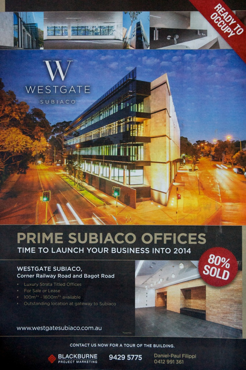
Here is a recent press advertisement for a new office building in Subiaco. The developers and photographer have found the best angle for the building to make it look good and help sell the office space. That camera position is about ten metres off the ground, at the second floor level. None us will ever see the building from that angle unless we hire a cherry picker and stand in the bucket high above the middle of the road.


This is how it appears for pedestrians at eye level. Not so good. The Railway Parade side of the building has eighty metres of blank wall punctuated with metal vents for the car park behind.


If you get back far enough, it looks OK, but for a person walking it offers nothing of interest. There is also no awning to provide any weather protection. An artist impression below, which must have been used during the pre-construction approval stages, shows a hedge on this side of the building. There is now no room for a hedge.


It is disappointing that the City of Subiaco has allowed such a bleak addition to the street scape. Imagine if every building was like this: it would be like walking in a concrete trench.

There are 133 cars bays in this building. 

+

The photographs show what 133 cars look like on the road. The City of Subiaco's outdated planning rules stipulate this is the minimum number that must park in the building. One car for every 40 square metres of office space.

It seems the City of Subiaco also have limited controls in place for how the parking is arranged. If the developers of Westgate had been required to put the parking below ground-level the street-level conditions for pedestrians could have been greatly improved. There is no basement in this building: there is a ground-level off Bagot Road, and another lower ground-level off Railway Road.

This building is 350 metres from the Daglish train station. The number 27 bus stops at the front door and the PSP (bike path) is only 50 metres away. This building has better transport connections than most of the office accommodation in St Georges Terrace, the heart of Perth's central business district.


Westgate in the City of Perth
If the Westgate building was constructed just two kilometres to the east, it would be out of the City of Subiaco and into the City of Perth's local government territory. The City of Perth have a completely different attitude to parking and the effect vehicle movements can have on a community. They stipulate  the maximum amount of parking allowable, not minimums. The calculations for car bays are done on land area and not lettable floor space. And they are much less. I am happy to be corrected, but my interpretation of the CoP parking policy gives a result of just 16 car bays if the Westgate building was over the border. 


That is a big difference:
  • 117 less cars in the lower levels of the building. Less blank walls and fewer vents. The architects could do something interesting with the ground floor. 
  • There would be over 230 less vehicle movements across the footpaths each day.
  • Out on the street, there would be a lot more people walking, using public transport and riding bicycles.

Westgate in the Town of Cambridge
Another comparison, which will make you despair if you care about walking. If Westgate was about one kilometre to the north of Subiaco, across the other border into the local government area called the Town of Cambridge, the number of car parking bays required in the same building would be 180. One car space for every 30 square metres of lettable office space.


Developers, if interested, have the ability to plea for a reduction in these numbers but with such a high starting position the negotiations may only give a reduction to levels that are still considered excessive in other local government areas.

For example, the developers of this mixed-use building under construction at 3 Loftus Street West Leederville managed to have the parking requirement reduced from 227 car bays to 129 (ToC council minutes PDF ).


Time to change the planning polices
There are parts of the Town of Cambridge, such as West Leederville, that are just two kilometres from the heart of Perth city. Subiaco is a similar distance. To have such dramatically different planning rules from the City of Perth makes no sense. These inner urban areas are really part of the city. These areas should be setting maximum parking requirements for buildings, not minimum.

Parts of the City of Subiaco look like this:


And there are parts of the City of Perth that look like this:


Trying to squeeze a lot of cars into buildings will continue to compromise the design and street scape in ways that are detrimental to pedestrians. We do not have to keep doing it.

If the The Shard was in the City of Subiaco instead of London? With its 110,000 square metres of floorspace it would be required to have a minimum of 2750 car bays.  It has just 47.